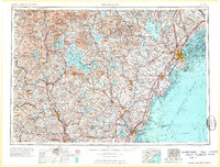
1963 Map of Portland
USGS Topo · Published 1963About this map
The northern New England coastline and the high peaks of the White Mountains define this mid-century landscape, anchored by the port of Portland and the industrial corridors of the Merrimack River. During the early 1960s, the region's transport network was a complex grid of Boston and Maine Railroad lines and developing federal highways like U.S. Highway 1, connecting the seacoast to the interior lake districts. Massive water bodies like Lake Winnipesaukee and Sebago Lake appear alongside vital Cold War military installations, including Pease Air Force Base and the Portsmouth Naval Shipyard. This era shows a transition from traditional rail-dependent commerce to a modern automotive and defense-linked economy, while the protected reaches of the White Mountain National Forest preserve the rugged character of the northern interior.
Find a feature on this map
349 named features on this map. Tap any name to fly to it.
Don’t see what you’re looking for? This feature index may not catch every label — zoom into the map to look around manually.
Map Details
Editions of this 1963 Portland Map
3 editions found

Other maps of this area

1888 · Newburyport
USGS Topo · 1:62,500

1888 · Haverhill
USGS Topo · 1:62,500

1890 · Haverhill
USGS Topo · 1:62,500

1890 · Newburyport
USGS Topo · 1:62,500

1891 · Portland
USGS Topo · 1:62,500

1891 · Biddeford
USGS Topo · 1:62,500

1891 · Berwick
USGS Topo · 1:62,500

1891 · Kennebunk
USGS Topo · 1:62,500

1891 · Buxton
USGS Topo · 1:62,500

1891 · Newfield
USGS Topo · 1:62,500