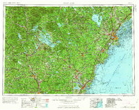
1963 Map of Portland
USGS Topo · Published 1963About this map
Portland and the southern coast of Maine anchor the eastern edge of this regional study, which extends west through the New Hampshire lakes region to the peaks of the White Mountains. The landscape is dominated by the massive waters of Lake Winnipesaukee and Sebago Lake, serving as recreational hubs for a network of settlements including Wolfeboro, Laconia, and Meredith. Near the coast, the Cold War military presence is visible at Pease AFB, while industrial centers like Biddeford and Saco sit at the fall lines of major rivers.
Find a feature on this map
99 named features on this map. Tap any name to fly to it.
Don’t see what you’re looking for? This feature index may not catch every label — zoom into the map to look around manually.
Map Details
Editions of this 1963 Portland Map
3 editions found

Other maps of this area

1888 · Newburyport
USGS Topo · 1:62,500

1888 · Haverhill
USGS Topo · 1:62,500

1890 · Haverhill
USGS Topo · 1:62,500

1890 · Newburyport
USGS Topo · 1:62,500

1891 · Portland
USGS Topo · 1:62,500

1891 · Biddeford
USGS Topo · 1:62,500

1891 · Berwick
USGS Topo · 1:62,500

1891 · Kennebunk
USGS Topo · 1:62,500

1891 · Buxton
USGS Topo · 1:62,500

1891 · Newfield
USGS Topo · 1:62,500