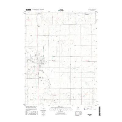
2016 Map of Portland
USGS Topo · Published 2016About this map
The Salamonie River meanders through the heart of Jay County, anchoring the settlement of Portland. This detailed 2016 survey illustrates the organized grid of the county seat alongside smaller surrounding hamlets such as Antiville, Pleasant Ridge, and Liber. The landscape is defined by an extensive network of drainage infrastructure, including Cartwright Ditch and McKinsey Ditch, which manage the water levels of the agricultural land surrounding the city. To the south, the Little Salamonie River and Buckeye Cr join the river system near the community of College Corner. For those researching local history or genealogy, the map identifies several significant burial grounds, including Green Park Cem, Baue Cem, and Liber Cem. Transport and infrastructure are represented by the Portland Municipal Airport and a dense network of numbered county roads and named city streets like W Votaw St and E Main St.
Find a feature on this map
76 named features on this map. Tap any name to fly to it.
Don’t see what you’re looking for? This feature index may not catch every label — zoom into the map to look around manually.
Map Details
Editions of this 2016 Portland Map
This is the sole edition of this map. No revisions or reprints were ever made.
Other maps of this area

1911 · Berne
USGS Topo · 1:48,000

1915 · Fort Recovery
USGS Topo · 1:48,000

1918 · Fort Recovery
USGS Topo · 1:62,500

1953 · Muncie
USGS Topo · 1:250,000

1956 · Muncie
USGS Topo · 1:250,000

1960 · Fort Recovery
USGS Topo · 1:24,000

1960 · Blaine
USGS Topo · 1:24,000
1960 · Portland
USGS Topo · 1:24,000
1960 · Cosmos
USGS Topo · 1:24,000

1960 · Ridgeville
USGS Topo · 1:24,000