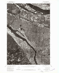
1975 Map of Portland
USGS Topo · Published 1979About this map
Portland reveals its mid-1970s industrial and urban density through this detailed orthophotographic perspective. Unlike traditional topographic sheets, this aerial imagery provides a direct view of the shipping channels and infrastructure lining the Willamette River as it flows toward the Columbia. The contrast between the heavily developed grid of the city and the high-elevation settlement at Sylvan highlights the complex geography of the West Hills. To the north, across the river, Vancouver is visible at the edge of the survey, showing the interconnected nature of these two major river cities. The 1975 photoimagery captures the specific layout of docks, rail yards, and residential neighborhoods before the urban shifts of the late twentieth century.
Find a feature on this map
3 named features on this map. Tap any name to fly to it.
Don’t see what you’re looking for? This feature index may not catch every label — zoom into the map to look around manually.
Map Details
Editions of this 1975 Portland Map
2 editions found
Other maps of this area

1897 · Portland
USGS Topo · 1:62,500

1905 · Portland
USGS Topo · 1:62,500

1914 · Oregon City
USGS Topo · 1:62,500

1915 · Hillsboro
USGS Topo · 1:62,500

1916 · Tualatin
USGS Topo · 1:62,500

1918 · Hillsboro
USGS Topo · 1:62,500

1939 · Oregon City
USGS Topo · 1:62,500

1939 · Tualatin
USGS Topo · 1:62,500

1940 · Tualatin
USGS Topo · 1:62,500

1940 · Hillsboro
USGS Topo · 1:62,500