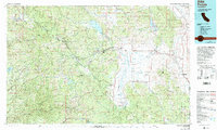
1979 Map of Portola
USGS Topo · Published 1993About this map
Middle Fork Feather River and the Western Pacific Railroad anchor the upper reaches of this northern Sierra Nevada survey, cutting through the Mohawk Valley toward the rail hub of Portola. The landscape is defined by its transition from the steep, timbered ridges of the Plumas National Forest to the wide, flat floor of the Sierra Valley, where agriculture and timber historically supported towns like Loyalton and Sierraville.
Find a feature on this map
62 named features on this map. Tap any name to fly to it.
Don’t see what you’re looking for? This feature index may not catch every label — zoom into the map to look around manually.
Map Details
Editions of this 1979 Portola Map
2 editions found
Other maps of this area

1886 · Honey Lake
USGS Topo · 1:250,000

1886 · Lassen Peak
USGS Topo · 1:250,000

1886 · Granite Range
USGS Topo · 1:250,000

1888 · Smartsville
USGS Topo · 1:125,000

1888 · Bidwell Bar
USGS Topo · 1:125,000

1890 · Sierraville
USGS Topo · 1:125,000

1891 · Bidwell Bar
USGS Topo · 1:125,000

1891 · Downieville
USGS Topo · 1:125,000

1891 · Honey Lake
USGS Topo · 1:250,000

1891 · Carson
USGS Topo · 1:125,000