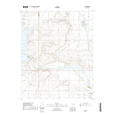
2018 Map of Porum
USGS Topo · Published 2018About this map
Porum sits at the intersection of a complex drainage system where the Canadian River meets the expansive reach of Eufaula Lake. This survey illustrates a landscape defined by significant elevation changes, from the prominent Tater Hill and Hi Early Mtn to the natural bottleneck of Porum Gap. The map documents the rural character of the region as three counties—Muskogee, McIntosh, and Haskell—converge near the river. Local genealogy is well-supported by the inclusion of multiple burial sites, including Coleman Cem, Hi Early Cem, Starr Cem, and Hoyt Cem. To the south, the settlement of Hoyt and the edge of Whitefield reflect the dispersed community patterns typical of eastern Oklahoma. Named water features like Belle Starr Cr and Tamaha Creek carve through the terrain, illustrating the hydrologic network that feeds into the major river valley and its associated bluffs, such as Taylor Bluff.
Find a feature on this map
65 named features on this map. Tap any name to fly to it.
Don’t see what you’re looking for? This feature index may not catch every label — zoom into the map to look around manually.
Map Details
Editions of this 2018 Porum Map
This is the sole edition of this map. No revisions or reprints were ever made.
Other maps of this area

1900 · Sansbois
USGS Topo · 1:125,000

1909 · Sans Bois
USGS Topo · 1:125,000

1911 · Sansbois
USGS Topo · 1:125,000

1946 · Fort Smith
USGS Topo · 1:250,000

1962 · Stigler West
USGS Topo · 1:24,000

1963 · Porum
USGS Topo · 1:24,000

1963 · Warner NW
USGS Topo · 1:24,000
1963 · Holt Mountain
USGS Topo · 1:24,000

1963 · Texanna
USGS Topo · 1:24,000
1963 · Warner
USGS Topo · 1:24,000