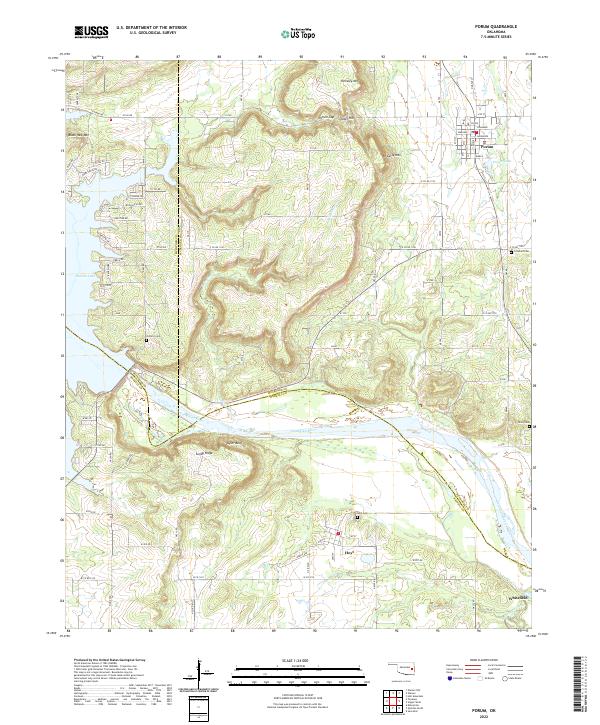
2022 Map of Porum
USGS Topo · Published 2022About this map
Porum and Hoyt anchor this topographic study of a rugged intersection where the borders of McIntosh, Muskogee, and Haskell Counties meet. The landscape is defined by the winding course of the Canadian River and the eastern reaches of Eufaula Lake, which create a complex shoreline near Taylor Bluff and Sandy Ridge. High points such as Black Haw Mtn, Hi Early Mtn, and Hensley Mtn overlook the lowlands, including the distinctive Porum Gap near Tater Hill. Local history is preserved through several rural burial grounds, including Hi Early Cem, Hoyt Cem, and Coleman Cem, scattered across the undulating terrain. The infrastructure shows a mix of established community centers and newer developments like Redland Acres, connected by a grid of county roads that navigate the creeks and valleys, most notably Belle Starr Cr and Emeachaya Creek.
Find a feature on this map
60 named features on this map. Tap any name to fly to it.
Don’t see what you’re looking for? This feature index may not catch every label — zoom into the map to look around manually.
Map Details
Editions of this 2022 Porum Map
This is the sole edition of this map. No revisions or reprints were ever made.
Other maps of this area

1900 · Sansbois
USGS Topo · 1:125,000

1909 · Sans Bois
USGS Topo · 1:125,000

1911 · Sansbois
USGS Topo · 1:125,000

1946 · Fort Smith
USGS Topo · 1:250,000

1962 · Stigler West
USGS Topo · 1:24,000

1963 · Porum
USGS Topo · 1:24,000

1963 · Warner NW
USGS Topo · 1:24,000
1963 · Holt Mountain
USGS Topo · 1:24,000

1963 · Texanna
USGS Topo · 1:24,000
1963 · Warner
USGS Topo · 1:24,000