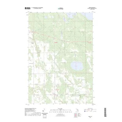
2023 Map of Posen
USGS Topo · Published 2023About this map
Posen serves as the primary hub in this northern Michigan landscape, where the local road network of Michigan Ave and State St meets the North Eastern State Trl. This trail corridor, following an old rail alignment, underscores the region's transition from a rail-dependent timber and agricultural economy to one focused on recreational land use. To the north, the small settlement of Liske sits near the headwaters of the Swan River, while the southern portion of the map is anchored by the Saint Casimir's Cem and the Farm Service Agency Interest of Michigan. The terrain is defined by a dense cluster of water bodies including Lake Augusta, Big Trout Lake, and Mud Lake, connected by the winding Little Trout River. This drainage pattern and the surrounding wetlands have historically dictated the placement of homesteads and connecting routes like Lake Augusta Hwy.
Find a feature on this map
47 named features on this map. Tap any name to fly to it.
Don’t see what you’re looking for? This feature index may not catch every label — zoom into the map to look around manually.
Map Details
Editions of this 2023 Posen Map
This is the sole edition of this map. No revisions or reprints were ever made.
Other maps of this area

1954 · Alpena
USGS Topo · 1:250,000

1955 · Hillman
USGS Topo · 1:62,500

1957 · Alpena
USGS Topo · 1:250,000

1958 · Alpena
USGS Topo · 1:250,000

1969 · Alpena
USGS Topo · 1:250,000

1971 · Long Lake West
USGS Topo · 1:24,000

1971 · Rogers City
USGS Topo · 1:24,000

1971 · Metz
USGS Topo · 1:24,000
1971 · Adams Point
USGS Topo · 1:24,000

1971 · Polaski
USGS Topo · 1:24,000