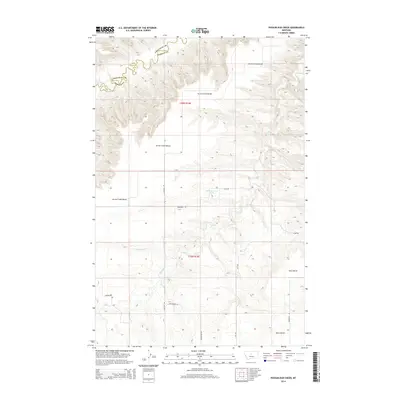
2014 Map of Possum Run Creek
USGS Topo · Published 2014About this map
Arrow Creek Bench dominates the high, flat landscape of this central Montana region, where the border of Chouteau Co and Fergus Co winds along the deeply incised path of Arrow Cr. This 2014 survey illustrates a rural landscape defined by expansive plateaus and the drainage networks of Coffee Cr and Possum Run Cr. The township and range lines of T20N R14E and T19N R14E organize the territory, which is accessible via a network of gravel and dirt routes such as N Denton Rd and Kingsbury Rd. The terrain is marked by significant elevation changes between the level surfaces of Alton Bench and the eroded coulees below. While largely open ranch land or agricultural ground, the presence of a mapped Spring and a named Rattlesnake Ln hint at the local landmarks and environmental features known to those who manage this Montana high country.
Find a feature on this map
17 named features on this map. Tap any name to fly to it.
Don’t see what you’re looking for? This feature index may not catch every label — zoom into the map to look around manually.
Map Details
Editions of this 2014 Possum Run Creek Map
This is the sole edition of this map. No revisions or reprints were ever made.
Other maps of this area

1890 · Fort Benton
USGS Topo · 1:250,000

1892 · Fort Benton
USGS Topo · 1:250,000

1897 · Fort Benton
USGS Topo · 1:250,000

1954 · Great Falls
USGS Topo · 1:250,000

1954 · Lewistown
USGS Topo · 1:250,000

1957 · Great Falls
USGS Topo · 1:250,000

1959 · Lewistown
USGS Topo · 1:250,000

1964 · Spring Coulee
USGS Topo · 1:24,000

1972 · Square Butte SE
USGS Topo · 1:24,000
1978 · Strouf Island
USGS Topo · 1:24,000