
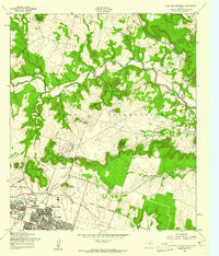
1958 Map of Post Oak Mountain
USGS Topo · Published 1979About this map
Fort Hood Military Reservation dominates this central Texas landscape, showing the massive scale of the installation's training grounds and aviation facilities during the late 1950s. The northern edge of Killeen appears at the bottom of the sheet, where residential growth including Walker Village and Meadows Sch pushes against the Military Reservation Boundary. The terrain is defined by a series of prominent peaks and gaps, including Post Oak Mountain, Sugar Loaf Mountain, and Castle Mountain, which overlook the winding path of Cowhouse Creek.
Find a feature on this map
40 named features on this map. Tap any name to fly to it.
Don’t see what you’re looking for? This feature index may not catch every label — zoom into the map to look around manually.
Map Details
Editions of this 1958 Post Oak Mountain Map
2 editions found
Other maps of this area

1894 · Gatesville
USGS Topo · 1:125,000

1924 · Gatesville 4-d
USGS Topo · 1:48,000

1924 · Gatesville 4-a
USGS Topo · 1:48,000

1930 · Killeen
USGS Topo · 1:62,500

1947 · Fort Hood
USGS Topo · 1:62,500

1947 · Bland
USGS Topo · 1:24,000

1947 · Fort Hood
USGS Topo · 1:24,000

1947 · Purmela
USGS Topo · 1:62,500

1947 · Post Oak Mountain
USGS Topo · 1:24,000

1947 · Killeen
USGS Topo · 1:62,500