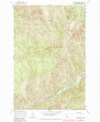
1965 Map of Pot Mountain
USGS Topo · Published 1984About this map
Pot Mountain dominates this remote landscape within the Clearwater National Forest, where steep ridgelines like Pot Mountain Ridge fall away into deep river drainages. The North Fork Clearwater River carves a winding path along the southern boundary, marked by river miles and unique features such as Survival Island. Human presence is largely defined by backcountry infrastructure and access points, including the Fourth of July Pack Bridge and the Weitas Creek Campground.
Find a feature on this map
36 named features on this map. Tap any name to fly to it.
Don’t see what you’re looking for? This feature index may not catch every label — zoom into the map to look around manually.
Map Details
Editions of this 1965 Pot Mountain Map
2 editions found
Other maps of this area

1911 · Lolo
USGS Topo · 1:250,000

1913 · Lolo
USGS Topo · 1:250,000

1923 · Washington Creek
USGS Topo · 1:125,000

1956 · Hamilton
USGS Topo · 1:250,000

1959 · Hamilton
USGS Topo · 1:250,000

1960 · Hamilton
USGS Topo · 1:250,000

1963 · Sheep Mtn
USGS Topo · 1:24,000
1963 · The Nub
USGS Topo · 1:24,000

1963 · Clarke Mtn
USGS Topo · 1:24,000
1963 · Elizabeth Lake
USGS Topo · 1:24,000