
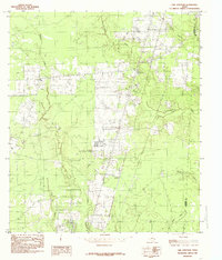
1984 Map of Potato Patch Lake
USGS Topo · Published 1985About this map
The Neches River meanders sharply through the heart of the Big Thicket National Preserve in this mid-1980s topographical study. This landscape is defined by its complex hydrology, where the river's shifting course has created numerous oxbows and secondary water bodies like Horseshoe Lake, Jackson Lake, and Clear Lake. The intersection of Tyler, Jasper, and Hardin counties is marked by these dense river bottomlands and wetlands.
Find a feature on this map
21 named features on this map. Tap any name to fly to it.
Don’t see what you’re looking for? This feature index may not catch every label — zoom into the map to look around manually.
Map Details
Editions of this 1984 Potato Patch Lake Map
This is the sole edition of this map. No revisions or reprints were ever made.
Other maps of this area

1952 · Lake Charles
USGS Topo · 1:250,000

1954 · Lake Charles
USGS Topo · 1:250,000

1954 · Beaumont
USGS Topo · 1:250,000

1955 · Silsbee
USGS Topo · 1:62,500

1955 · Bessmay
USGS Topo · 1:62,500

1957 · Beaumont
USGS Topo · 1:250,000

1958 · Spurger
USGS Topo · 1:62,500

1958 · Kirbyville
USGS Topo · 1:62,500

1984 · Beaumont
USGS Topo · 1:250,000
1984 · Call Junction
USGS Topo · 1:24,000