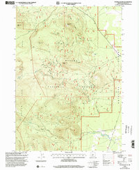
1999 Map of Pothole Butte
USGS Topo · Published 2002About this map
The eastern boundary of Crater Lake National Park meets the volcanic terrain of the Winema National Forest in this 1999 revision. The landscape is defined by its prominent volcanic rises, notably Pothole Butte, Lookout Butte, and Bear Butte, which overlook a network of seasonal water sources including Pothole Spring and Pothole Well. To the east, the elevation drops toward the Antelope Desert, marking a transition from forested uplands to more arid flats. Evidence of local industry or road construction appears at the Cinder Pit near the northern boundary. The intricate drainage patterns of Bear Creek, Scott Creek, and Pothole Creek reveal a landscape shaped by seasonal runoff and volcanic geology. This survey provides a precise look at the backcountry borders of the national park system during the late 1990s.
Find a feature on this map
15 named features on this map. Tap any name to fly to it.
Don’t see what you’re looking for? This feature index may not catch every label — zoom into the map to look around manually.
Map Details
Editions of this 1999 Pothole Butte Map
This is the sole edition of this map. No revisions or reprints were ever made.
Other maps of this area

1889 · Klamath
USGS Topo · 1:250,000

1891 · Ashland
USGS Topo · 1:250,000

1893 · Ashland
USGS Topo · 1:250,000

1894 · Klamath
USGS Topo · 1:250,000

1897 · Ashland
USGS Topo · 1:250,000

1917 · Diamond Lake
USGS Topo · 1:125,000

1935 · Chemult
USGS Topo · 1:96,000

1941 · Chemult
USGS Topo · 1:125,000

1955 · Crescent
USGS Topo · 1:250,000

1955 · Klamath Falls
USGS Topo · 1:250,000