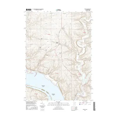
2016 Map of Potosi
USGS Topo · Published 2016About this map
The rugged driftless topography of Grant County meets the wide expanse of the Mississippi River in this 2016 record of the Wisconsin-Iowa border. The settlement pattern follows the intricate network of coulees and hollows, where small communities like Potosi, Tennyson, and British Hollow are positioned along the winding valley floors. This area's long mining and brewing history is reflected in names like Brewery Hollow Rd and British Hollow, while the agricultural character is maintained across the high ridges. Genealogical landmarks are prominent, including Saint Thomas Cem, British Hollow Cem, and the Van Buren Cem. The map captures the significant transition from the upland bluffs down to the river bottoms at Island Number Two Hundred Eleven, where the state line divides the channel between Wisconsin and Iowa.
Find a feature on this map
67 named features on this map. Tap any name to fly to it.
Don’t see what you’re looking for? This feature index may not catch every label — zoom into the map to look around manually.
Map Details
Editions of this 2016 Potosi Map
This is the sole edition of this map. No revisions or reprints were ever made.
Other maps of this area

1900 · Lancaster
USGS Topo · 1:125,000

1904 · Lancaster
USGS Topo · 1:125,000

1908 · Lancaster
USGS Topo · 1:125,000

1955 · Balltown
USGS Topo · 1:24,000

1956 · Dubuque North
USGS Topo · 1:24,000

1956 · Sherrill
USGS Topo · 1:24,000

1957 · Potosi
USGS Topo · 1:24,000

1959 · Dubuque
USGS Topo · 1:250,000

1961 · Dubuque
USGS Topo · 1:250,000
1961 · Dickeyville
USGS Topo · 1:24,000