
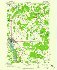
1943 Map of Potsdam
USGS Topo · Published 1943About this map
The Raquette River and St Regis River carve through this section of St. Lawrence County, defining a mid-century landscape where industrial water power meets rural village life. In Potsdam, the river is heavily utilized, featuring the Sugar Island Dam and a Surge Tank alongside Sugar Island. This 1943 survey, conducted by the Tennessee Valley Authority for the War Department, shows the critical transportation role of the New York Central Railroad as it connects Norwood and Sisson to the wider region. Outside the primary hubs, the terrain is dotted with numbered district schools like School No 20 and School No 9, reflecting the era's decentralized educational system. Local genealogy is well-preserved through several burial grounds, including Bayside Cem, Riverside Cem, and Calvary Cem, while small crossroads like Sandfordville and West Stockholm anchor the agricultural and residential districts north of Parishville Center.
Find a feature on this map
86 named features on this map. Tap any name to fly to it.
Don’t see what you’re looking for? This feature index may not catch every label — zoom into the map to look around manually.
Map Details
Editions of this 1943 Potsdam Map
2 editions found
Other maps of this area

1905 · Waddington
USGS Topo · 1:62,500

1906 · Massena
USGS Topo · 1:62,500

1907 · Massena
USGS Topo · 1:62,500

1908 · Potsdam
USGS Topo · 1:62,500

1910 · Canton
USGS Topo · 1:62,500

1911 · Canton
USGS Topo · 1:62,500

1942 · Long Bow
USGS Topo · 1:24,000

1942 · Chase Mills
USGS Topo · 1:24,000

1942 · Norfolk
USGS Topo · 1:24,000
1943 · Colton
USGS Topo · 1:31,680