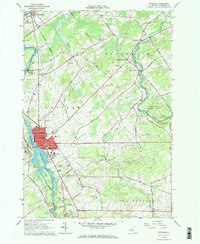
1964 Map of Potsdam
USGS Topo · Published 1973About this map
Potsdam serves as the academic and industrial anchor of this mid-century survey, defined by the presence of Clarkson College and the State Teachers College. The Raquette River bisects the village, passing landmark public spaces like Ives Park and Cubley Park while supporting local infrastructure at the Gaging Station and the Spillway. The surrounding landscape of Stockholm and Parishville is a mosaic of agricultural plots and gravel operations, with the New York Central Railroad providing a critical transportation corridor through Norwood. To the east, the St. Regis River winds through St. Lawrence State Forest No. 23, past the small hamlets of West Stockholm and Sandfordville. Genealogists will find significant detail in the numerous burial grounds, including Old St. Marys Cem and Calvary Cemetery, which mark the settlement history of the river valleys.
Find a feature on this map
89 named features on this map. Tap any name to fly to it.
Don’t see what you’re looking for? This feature index may not catch every label — zoom into the map to look around manually.
Map Details
Editions of this 1964 Potsdam Map
3 editions found
Other maps of this area

1905 · Waddington
USGS Topo · 1:62,500

1906 · Massena
USGS Topo · 1:62,500

1907 · Massena
USGS Topo · 1:62,500

1908 · Potsdam
USGS Topo · 1:62,500

1910 · Canton
USGS Topo · 1:62,500

1911 · Canton
USGS Topo · 1:62,500

1942 · Long Bow
USGS Topo · 1:24,000

1942 · Chase Mills
USGS Topo · 1:24,000

1942 · Norfolk
USGS Topo · 1:24,000

1943 · Potsdam
USGS Topo · 1:31,680