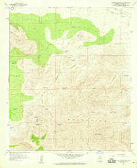
1958 Map of Potter Mountain
USGS Topo · Published 1959About this map
The Mule Mountains dominate the high-elevation landscape of this Cochise County region during the late 1950s. The terrain is characterized by a sophisticated network of water management features essential for ranching and survival in the arid Arizona environment. Named water sources such as Little Sandy Spring, Bull Spring, and the Sack Tongue Tank are scattered across the slopes, supported by numerous mechanical lifelines like the Owl Hoot Windmill and Blacktail Windmill.
Find a feature on this map
33 named features on this map. Tap any name to fly to it.
Don’t see what you’re looking for? This feature index may not catch every label — zoom into the map to look around manually.
Map Details
Editions of this 1958 Potter Mountain Map
2 editions found
Other maps of this area

1902 · Bisbee
USGS Topo · 1:62,500

1910 · Bisbee
USGS Topo · 1:62,500

1914 · Hereford
USGS Topo · 1:125,000

1915 · Benson
USGS Topo · 1:125,000

1916 · Pearce
USGS Topo · 1:125,000

1916 · Douglas
USGS Topo · 1:125,000

1919 · Douglas
USGS Topo · 1:125,000

1925 · Gleeson
USGS Topo · 1:62,500

1927 · Bisbee
USGS Topo · 1:62,500

1932 · Stark
USGS Topo · 1:62,500