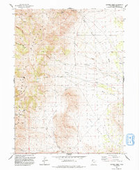
1991 Map of Potters Creek
USGS Topo · Published 1991About this map
The Grouse Creek Mountains dominate this high-desert landscape in northern Utah, where a complex network of seasonal drainages and springs defines the pattern of movement and land use. Near the southern edge of the range, Ingham Peak and Ingham Pass provide landmarks for navigating the transition toward the lowlands of Dry Basin. The map captures a moment in the early 1990s when 4WD tracks were the primary means of traversing the high country, connecting remote sites like the Prospect mine and the Stoke Spring Corral. Water sources such as Rosebud Spring and the multiple forks of Birch Creek and Little Birch Creek indicate the vital hydrology supporting livestock in the Buck Pasture area. This survey provides an essential view of the region's ranching and mineral exploration history.
Find a feature on this map
28 named features on this map. Tap any name to fly to it.
Don’t see what you’re looking for? This feature index may not catch every label — zoom into the map to look around manually.
Map Details
Editions of this 1991 Potters Creek Map
This is the sole edition of this map. No revisions or reprints were ever made.
Other maps of this area

1954 · Brigham City
USGS Topo · 1:250,000

1958 · Brigham City
USGS Topo · 1:250,000

1959 · Cotton Thomas Basin
USGS Topo · 1:62,500

1959 · Yost
USGS Topo · 1:62,500

1962 · Brigham City
USGS Topo · 1:250,000

1971 · Prohibition Spring
USGS Topo · 1:24,000

1971 · Emigrant Pass
USGS Topo · 1:24,000

1971 · Potters Creek
USGS Topo · 1:24,000
1971 · Rocky Pass Peak
USGS Topo · 1:24,000

1971 · Warm Spring Hills
USGS Topo · 1:24,000