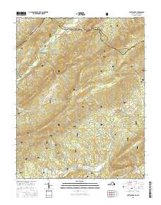
2016 Map of Potts Creek
USGS Topo · Published 2016About this map
Potts Mountain and Peters Mountain frame this corridor of the Allegheny mountains along the border of Virginia and West Virginia. This 2016 survey captures a landscape defined by sharp ridges and deep valleys, including the prominent Hanging Rock Valley and Red Brush Valley. The area is largely preserved within the George Washington National Forest and Jefferson National Forest, with a few small settlements such as Potts Creek and Potts Cove situated near the water. Genealogists will find several remote burial sites, including the Rowan Memorial Home Cem, Ruble Cem, and Paxton Cem, which are scattered among the ridges. The intricate drainage network of Potts Creek and its many tributaries, like Shawvers Run and Cold Spring Br, illustrate how the terrain has dictated local movement and settlement patterns for generations.
Find a feature on this map
53 named features on this map. Tap any name to fly to it.
Don’t see what you’re looking for? This feature index may not catch every label — zoom into the map to look around manually.
Map Details
Editions of this 2016 Potts Creek Map
This is the sole edition of this map. No revisions or reprints were ever made.
Other maps of this area

1887 · Lewisburg
USGS Topo · 1:125,000

1890 · Christiansburg
USGS Topo · 1:125,000

1891 · Lewisburg
USGS Topo · 1:125,000

1921 · Ronceverte
USGS Topo · 1:48,000

1923 · Ronceverte
USGS Topo · 1:62,500

1923 · Waiteville
USGS Topo · 1:62,500

1929 · Salem
USGS Topo · 1:48,000

1931 · Waiteville
USGS Topo · 1:48,000

1932 · Salem
USGS Topo · 1:62,500

1944 · Waiteville
USGS Topo · 1:62,500