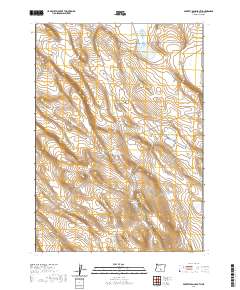
2020 Map of Poverty Basin South
USGS Topo · Published 2020About this map
Poverty Basin characterizes this high-desert reach of Lake County, where the management of water defines the human and natural footprint. The landscape is marked by a series of engineered catchments, including the ZX Reservoir Number 1 and Brattain Reservoir Number 11, reflecting the long-standing ranching traditions of the Oregon outback. These water features, alongside the Poverty Corners Waterhole and Knob Waterhole, are critical landmarks in a region defined by its arid climate and vast grazing allotments. The map detail illustrates the complex network of section lines and township boundaries, such as t30s r21e and t31s r22e, which organize this open range into a functional agricultural and topographic grid.
Find a feature on this map
9 named features on this map. Tap any name to fly to it.
Don’t see what you’re looking for? This feature index may not catch every label — zoom into the map to look around manually.
Map Details
Editions of this 2020 Poverty Basin South Map
This is the sole edition of this map. No revisions or reprints were ever made.
Other maps of this area

1955 · Crescent
USGS Topo · 1:250,000

1955 · Klamath Falls
USGS Topo · 1:250,000

1957 · Crescent
USGS Topo · 1:250,000

1958 · Crescent
USGS Topo · 1:250,000

1958 · Klamath Falls
USGS Topo · 1:250,000

1970 · Crescent
USGS Topo · 1:250,000

1974 · Lake Abert
USGS Topo · 1:100,000
1984 · Coleman Hills
USGS Topo · 1:24,000
1984 · Alkali Buttes
USGS Topo · 1:24,000
1984 · Sawed Horn
USGS Topo · 1:24,000