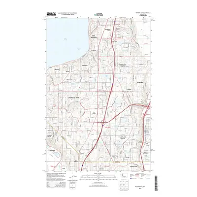
2014 Map of Poverty Bay
USGS Topo · Published 2014About this map
Poverty Bay and the shoreline of Puget Sound define the western edge of this 2014 survey, where the residential expansion of South King County meets the industrial corridors of the Puyallup Valley. The map captures a densely developed landscape stretching from Des Moines and Federal Way south toward Tacoma. Local history is preserved in small enclaves like Kitts Corner and the numerous cemeteries including Gethsemane Cem and Georges Cem. The terrain is punctuated by a high concentration of glacial kettle lakes, such as Lake Geneva, Lake Killarney, and Steel Lake, which serve as recreational focal points within the suburban grid. Major transportation routes like Pacific Hwy S and the Weyerhaeuser Way S corridor facilitate the movement of people and commerce through this critical nexus of the Puget Sound region.
Find a feature on this map
112 named features on this map. Tap any name to fly to it.
Don’t see what you’re looking for? This feature index may not catch every label — zoom into the map to look around manually.
Map Details
Editions of this 2014 Poverty Bay Map
This is the sole edition of this map. No revisions or reprints were ever made.
Other maps of this area

1897 · Tacoma
USGS Topo · 1:125,000

1900 · Tacoma
USGS Topo · 1:125,000

1941 · Tacoma South
USGS Topo · 1:62,500

1942 · Lake Tapps
USGS Topo · 1:62,500

1944 · Lake Tapps
USGS Topo · 1:62,500

1944 · Tacoma South
USGS Topo · 1:62,500

1949 · Tacoma North
USGS Topo · 1:24,000

1949 · Poverty Bay
USGS Topo · 1:24,000

1949 · Renton
USGS Topo · 1:24,000
1949 · Des Moines
USGS Topo · 1:24,000