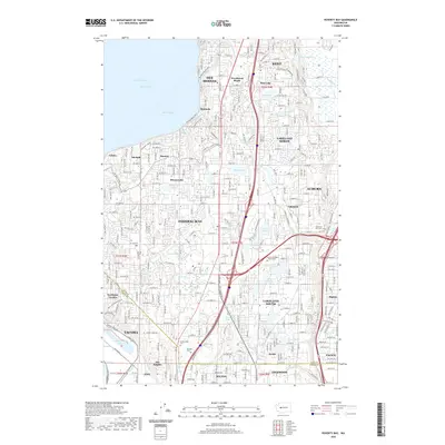
2020 Map of Poverty Bay
USGS Topo · Published 2020About this map
Poverty Bay and the shoreline of Puget Sound define the western edge of this dense coastal corridor. The landscape is characterized by a high concentration of small kettle lakes and ponds, including Steel Lake, Lake Geneva, and Star Lake, which are interspersed among the expanding residential footprints of Federal Way, Des Moines, and Auburn. This 2020 layout reveals a highly developed infrastructure of local connectors like Military Rd S and Dash Point Rd that weave between older established neighborhoods like Woodmont Beach and Adelaide.
Find a feature on this map
146 named features on this map. Tap any name to fly to it.
Don’t see what you’re looking for? This feature index may not catch every label — zoom into the map to look around manually.
Map Details
Editions of this 2020 Poverty Bay Map
This is the sole edition of this map. No revisions or reprints were ever made.
Other maps of this area

1897 · Tacoma
USGS Topo · 1:125,000

1900 · Tacoma
USGS Topo · 1:125,000

1941 · Tacoma South
USGS Topo · 1:62,500

1942 · Lake Tapps
USGS Topo · 1:62,500

1944 · Lake Tapps
USGS Topo · 1:62,500

1944 · Tacoma South
USGS Topo · 1:62,500

1949 · Tacoma North
USGS Topo · 1:24,000

1949 · Poverty Bay
USGS Topo · 1:24,000

1949 · Renton
USGS Topo · 1:24,000
1949 · Des Moines
USGS Topo · 1:24,000