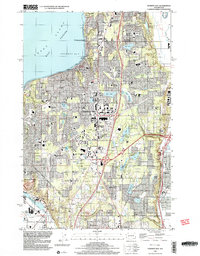
1997 Map of Poverty Bay
USGS Topo · Published 2003About this map
Federal Way serves as the central anchor of this 1990s-era coastal survey, revealing a landscape of dense residential growth and commercial development along the Pacific Hwy S. The shoreline along Poverty Bay and Puget Sound East Passage is punctuated by established communities like Woodmont Beach and Redondo, while the interior is dotted with a high concentration of schools and parks. Features such as the Sea-Tac Mall and City Center Park highlight the urban evolution of the region.
Find a feature on this map
69 named features on this map. Tap any name to fly to it.
Don’t see what you’re looking for? This feature index may not catch every label — zoom into the map to look around manually.
Map Details
Editions of this 1997 Poverty Bay Map
This is the sole edition of this map. No revisions or reprints were ever made.
Other maps of this area

1897 · Tacoma
USGS Topo · 1:125,000

1900 · Tacoma
USGS Topo · 1:125,000

1941 · Tacoma South
USGS Topo · 1:62,500

1942 · Lake Tapps
USGS Topo · 1:62,500

1944 · Lake Tapps
USGS Topo · 1:62,500

1944 · Tacoma South
USGS Topo · 1:62,500

1949 · Tacoma North
USGS Topo · 1:24,000

1949 · Poverty Bay
USGS Topo · 1:24,000

1949 · Renton
USGS Topo · 1:24,000
1949 · Des Moines
USGS Topo · 1:24,000