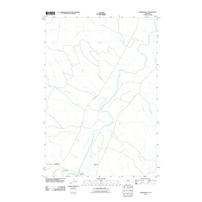
2011 Map of Powderville
USGS Topo · Published 2011About this map
The meandering Powder River defines the central corridor of this eastern Montana landscape, anchoring a network of drainages that support the small settlement of Powderville. This ranching country is marked by local landmarks like Soldiers Mount and Flintheart Draw, which rise above the surrounding creek beds. The community core is identified by the Powderville Community Hall, a gathering point for the rural population of Powder River County. Cultural and historical depth is evident at the Boothill Cemetery, situated on the western edge of the settlement area. Transport through this prairie terrain follows the winding paths of Powder River Rd and Brewer Rd, which provide access to the various tributary basins including Deep Creek, Stump Creek, and Timber Creek. The map documents a landscape where traditional water sources and low-lying draws remain the primary points of orientation for navigation and land use.
Find a feature on this map
19 named features on this map. Tap any name to fly to it.
Don’t see what you’re looking for? This feature index may not catch every label — zoom into the map to look around manually.
Map Details
Editions of this 2011 Powderville Map
This is the sole edition of this map. No revisions or reprints were ever made.
Other maps of this area

1954 · Ekalaka
USGS Topo · 1:250,000

1956 · Ekalaka
USGS Topo · 1:250,000

1958 · Ekalaka
USGS Topo · 1:250,000

1965 · Ekalaka
USGS Topo · 1:250,000

1979 · Blacktail Creek NW
USGS Topo · 1:24,000
1979 · Mills Creek East
USGS Topo · 1:24,000

1979 · Blacktail Creek SW
USGS Topo · 1:24,000

1979 · Powderville
USGS Topo · 1:24,000
1979 · Mills Creek West
USGS Topo · 1:24,000

1979 · Rattlesnake Ridge
USGS Topo · 1:24,000