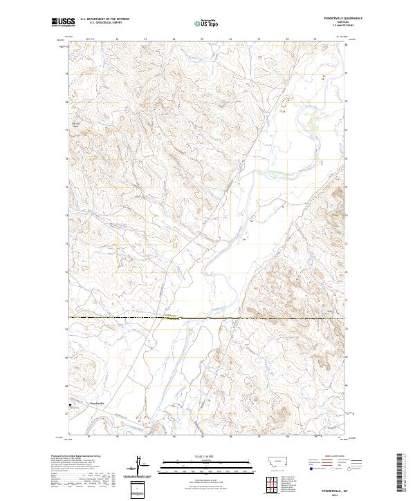
2024 Map of Powderville
USGS Topo · Published 2024About this map
Powderville anchors this modern topographic perspective of the high plains, situated near the southern bend of the Powder River. This isolated settlement remains a significant landmark in a landscape defined by its intricate drainage networks, where ephemeral streams like Ash Creek, Timber Creek, and Meadow Creek carve through the terrain. The map traces the county line where Custer Co meets Powder River Co, a boundary that bisects the rolling geography of the region. Notable landmarks such as Chimney Butte and Boothill Cem provide specific points of interest for those researching the local history or genealogy of this rural Montana community. The road network, including Powderville Rd and Ekalaka Rd, follows the natural contours and watercourses, illustrating how travel in this region is still dictated by the flow of the Powder River.
Find a feature on this map
31 named features on this map. Tap any name to fly to it.
Don’t see what you’re looking for? This feature index may not catch every label — zoom into the map to look around manually.
Map Details
Editions of this 2024 Powderville Map
This is the sole edition of this map. No revisions or reprints were ever made.
Other maps of this area

1954 · Ekalaka
USGS Topo · 1:250,000

1956 · Ekalaka
USGS Topo · 1:250,000

1958 · Ekalaka
USGS Topo · 1:250,000

1965 · Ekalaka
USGS Topo · 1:250,000

1979 · Blacktail Creek NW
USGS Topo · 1:24,000
1979 · Mills Creek East
USGS Topo · 1:24,000

1979 · Blacktail Creek SW
USGS Topo · 1:24,000

1979 · Powderville
USGS Topo · 1:24,000
1979 · Mills Creek West
USGS Topo · 1:24,000

1979 · Rattlesnake Ridge
USGS Topo · 1:24,000