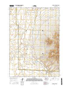
2017 Map of Powell Butte
USGS Topo · Published 2017About this map
Powell Butte sits at the northern edge of this high-desert landscape where the irrigated plains of the High Desert meet the volcanic rises of the Powell Buttes. The geography is defined by a series of seasonal and intermittent water features, including the winding course of the Dry River and the ephemeral Shumway Lake. A network of rural roads, many bearing local family names like Bozarth Rd, Shumway Rd, and Hahlen Ave, crisscross the townships of t15s r14e and t16s r14e. The presence of the Coi Canal Rd in the northeast indicates the vital role of water management in this arid region of Central Oregon, while the isolated Picket Spring provides a rare natural water source tucked into the higher elevations.
Find a feature on this map
58 named features on this map. Tap any name to fly to it.
Don’t see what you’re looking for? This feature index may not catch every label — zoom into the map to look around manually.
Map Details
Editions of this 2017 Powell Butte Map
This is the sole edition of this map. No revisions or reprints were ever made.
Other maps of this area

1926 · Bend
USGS Topo · 1:125,000

1929 · Bend
USGS Topo · 1:125,000

1955 · Bend
USGS Topo · 1:250,000

1957 · Bend
USGS Topo · 1:250,000

1958 · Bend
USGS Topo · 1:250,000

1961 · Redmond
USGS Topo · 1:24,000

1962 · Forked Horn Butte
USGS Topo · 1:24,000

1962 · Oneil
USGS Topo · 1:24,000
1962 · Bend Airport
USGS Topo · 1:24,000

1962 · Huston Lake
USGS Topo · 1:24,000