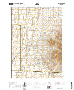
2020 Map of Powell Butte
USGS Topo · Published 2020About this map
The rising topography of the Powell Buttes dominates this high-desert landscape in central Oregon, sitting just south of the community of Powell Butte. This modern record of the area shows a complex transition between the agricultural and residential development to the north and the increasingly relief-heavy terrain of the buttes to the south. The intermittent path of the Dry River snakes through the center of the sheet, while Shumway Lake sits near the junction of SW Alfafa Rd and SW Shumway Rd. A dense network of local routes, many named after regional peaks such as SW Mt Hood Dr and SW Mt Adams Loop, reflects the area's growth and subdivision. Along the eastern slopes of the buttes, Picket Spring provides a rare water source among the contour-packed hillsides, while the COI Canal Rd traces the infrastructure supporting local irrigation.
Find a feature on this map
71 named features on this map. Tap any name to fly to it.
Don’t see what you’re looking for? This feature index may not catch every label — zoom into the map to look around manually.
Map Details
Editions of this 2020 Powell Butte Map
This is the sole edition of this map. No revisions or reprints were ever made.
Other maps of this area

1926 · Bend
USGS Topo · 1:125,000

1929 · Bend
USGS Topo · 1:125,000

1955 · Bend
USGS Topo · 1:250,000

1957 · Bend
USGS Topo · 1:250,000

1958 · Bend
USGS Topo · 1:250,000

1961 · Redmond
USGS Topo · 1:24,000

1962 · Forked Horn Butte
USGS Topo · 1:24,000

1962 · Oneil
USGS Topo · 1:24,000
1962 · Bend Airport
USGS Topo · 1:24,000

1962 · Huston Lake
USGS Topo · 1:24,000