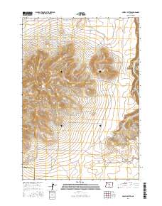
2017 Map of Powell Buttes
USGS Topo · Published 2017About this map
Powell Buttes rise prominently above the central Oregon high desert, anchoring a landscape where the Crook Co / Deschutes Co line bisects the high ground. The northeastern edge of the sheet is defined by the winding course of the Crooked River, while the southern slopes descend toward Swartz Canyon. This era of the landscape is marked by a network of rural residential roads in the northwest, including SW Nicole Dr and SW Valley View Rd, contrasting with the more open, traditional ranching land to the south and east.
Find a feature on this map
40 named features on this map. Tap any name to fly to it.
Don’t see what you’re looking for? This feature index may not catch every label — zoom into the map to look around manually.
Map Details
Editions of this 2017 Powell Buttes Map
This is the sole edition of this map. No revisions or reprints were ever made.
Other maps of this area

1926 · Bend
USGS Topo · 1:125,000

1929 · Bend
USGS Topo · 1:125,000

1955 · Bend
USGS Topo · 1:250,000

1957 · Bend
USGS Topo · 1:250,000

1958 · Bend
USGS Topo · 1:250,000

1962 · Oneil
USGS Topo · 1:24,000

1962 · Huston Lake
USGS Topo · 1:24,000
1962 · Alfalfa
USGS Topo · 1:24,000

1962 · Prineville
USGS Topo · 1:24,000

1962 · Powell Buttes
USGS Topo · 1:62,500