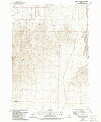
1988 Map of Powell Buttes
USGS Topo · Published 1988About this map
Powell Buttes dominates the central landscape of this late-twentieth-century survey, rising sharply above the surrounding high desert and ranch lands of Central Oregon. The map documents a rugged volcanic topography defined by named outcrops like Hat Rock and Rooster Comb, alongside an extensive network of water sources such as Wells Spring, Casey Spring, and Stotz Spring. In the lower elevations, human settlement is marked by the Red Cloud Ranch and Three Spring Ranch, while the Central Oregon Canal and its associated levee system in the northwest illustrate the essential infrastructure required for agriculture in this arid environment. The eastern edge is defined by the winding course of the Crooked River as it passes through Swartz Canyon, highlighting the geological transition from the buttes to the river basin.
Find a feature on this map
26 named features on this map. Tap any name to fly to it.
Don’t see what you’re looking for? This feature index may not catch every label — zoom into the map to look around manually.
Map Details
Editions of this 1988 Powell Buttes Map
This is the sole edition of this map. No revisions or reprints were ever made.
Other maps of this area

1926 · Bend
USGS Topo · 1:125,000

1929 · Bend
USGS Topo · 1:125,000

1955 · Bend
USGS Topo · 1:250,000

1957 · Bend
USGS Topo · 1:250,000

1958 · Bend
USGS Topo · 1:250,000

1962 · Oneil
USGS Topo · 1:24,000

1962 · Huston Lake
USGS Topo · 1:24,000
1962 · Alfalfa
USGS Topo · 1:24,000

1962 · Prineville
USGS Topo · 1:24,000

1962 · Powell Buttes
USGS Topo · 1:62,500