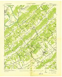
1936 Map of Powell Station
USGS Topo · Published 1936About this map
Powell Station and the surrounding Tennessee Valley are recorded here during a period of transition under the Tennessee Valley Authority. The landscape is defined by the prominent ridges of Chestnut Ridge and Copper Ridge, with the Clinch River winding through the northwest corner near Clinton. Significant infrastructure projects from the era are visible, including CCC Camp No 495 and the Clinton Forest Nursery. Local industry and social life are anchored by numerous small-scale operations like Fleenors Mill and Dad Mill, alongside a dense network of country churches such as Deep Springs Ch and Lonesome Dove Ch. The Southern Railway serves as a primary transit corridor, connecting the settlements of Heiskell and Glenwood to the broader region.
Find a feature on this map
77 named features on this map. Tap any name to fly to it.
Don’t see what you’re looking for? This feature index may not catch every label — zoom into the map to look around manually.
Map Details
Editions of this 1936 Powell Station Map
This is the sole edition of this map. No revisions or reprints were ever made.
Other maps of this area

1886 · Knoxville
USGS Topo · 1:125,000

1892 · Knoxville
USGS Topo · 1:125,000

1893 · Briceville
USGS Topo · 1:125,000

1894 · Knoxville
USGS Topo · 1:125,000

1895 · Loudon
USGS Topo · 1:125,000

1895 · Briceville
USGS Topo · 1:125,000

1895 · Knoxville
USGS Topo · 1:125,000

1896 · Briceville
USGS Topo · 1:125,000

1897 · Maynardville
USGS Topo · 1:125,000

1900 · Maynardville
USGS Topo · 1:125,000