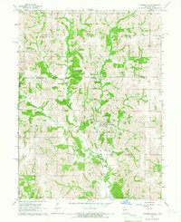
1964 Map of Powersville
USGS Topo · Published 1966About this map
The northern Missouri borderlands meet the Iowa state line in this mid-1960s survey, dominated by the diverging branches of Medicine Creek. The landscape is defined by the Chicago Milwaukee St Paul and Pacific railroad, which cuts a diagonal path through the township of York and past the central village of Powersville. This settlement serves as a local hub for the surrounding agricultural tracts in both Iowa Missouri and Iowa, with its namesake Powersville Cem situated nearby. Numerous family and community burial grounds are scattered across the terrain, including Wyreka Cem and Medicineville Cem, offering significant data points for genealogists tracking local ancestry in Wayne Co Putnam Co and Wayne Co Putnam Co. The map also captures the subtle drainage patterns of Middle Fork Medicine Creek and Buckworth Creek, illustrating the natural watercourses that shaped early land divisions.
Find a feature on this map
19 named features on this map. Tap any name to fly to it.
Don’t see what you’re looking for? This feature index may not catch every label — zoom into the map to look around manually.
Map Details
Editions of this 1964 Powersville Map
This is the sole edition of this map. No revisions or reprints were ever made.
Other maps of this area

1942 · Seymour
USGS Topo · 1:62,500

1944 · Seymour
USGS Topo · 1:62,500

1954 · Centerville
USGS Topo · 1:250,000

1957 · Centerville
USGS Topo · 1:250,000

1958 · Centerville
USGS Topo · 1:250,000

1964 · Pollock NW
USGS Topo · 1:24,000

1964 · Ravanna
USGS Topo · 1:24,000

1964 · Lucerne
USGS Topo · 1:24,000

1964 · Allerton
USGS Topo · 1:24,000

1964 · Cleopatra
USGS Topo · 1:24,000