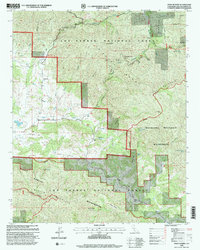
1995 Map of Pozo Summit
USGS Topo · Published 2000About this map
Pozo sits at a geographic crossroads within the Los Padres National Forest, where the Salinas River and Creek drain the surrounding highlands. This mid-1990s revision reveals a landscape defined by ranching and wilderness preservation, featuring the historic Pozo School and scattered settlements like Las Chiches and Soto. The terrain transitions from the alluvial reaches of Turkey Flat to the high elevations of the La Panza Range, with the Pozo Summit and La Panza Summit marking the ridge lines. Specialized land use is evident through the inclusion of a Landing Strip and the primitive OHV Road networks that navigate the Machesna Mountain Wilderness and Garcia Mountain Wilderness. Remote water sources, such as American Canyon Spring and Pine Mountain Springs, illustrate the critical infrastructure required for managing these protected California coastal ranges.
Find a feature on this map
43 named features on this map. Tap any name to fly to it.
Don’t see what you’re looking for? This feature index may not catch every label — zoom into the map to look around manually.
Map Details
Editions of this 1995 Pozo Summit Map
This is the sole edition of this map. No revisions or reprints were ever made.
Other maps of this area

1922 · Pozo
USGS Topo · 1:62,500

1922 · Nipomo
USGS Topo · 1:62,500

1932 · La Panza
USGS Topo · 1:48,000

1935 · La Panza
USGS Topo · 1:62,500

1936 · La Panza
USGS Topo · 1:62,500

1937 · Branch Mtn
USGS Topo · 1:48,000

1942 · Branch Mountain
USGS Topo · 1:62,500

1947 · San Luis Obispo
USGS Topo · 1:250,000

1948 · San Luis Obispo
USGS Topo · 1:250,000
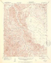
1952 · La Panza
USGS Topo · 1:62,500