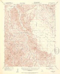
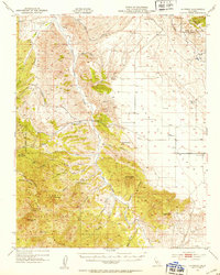
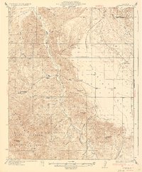
1952 Map of La Panza
USGS Topo · Published 1953About this map
La Panza and the surrounding high desert terrain are defined by the convergence of the Temblor Range and the southern reaches of the Los Padres National Forest. Based on field work from the 1920s with early 1950s cultural updates, this sheet captures the transition from cattle ranching to early petroleum exploration. Small outposts like French Camp and Pinole Ranch are situated along the drainage of San Juan Creek, while the presence of an Oil Well (Aband) near Freeborn Mtn hints at the mid-century industrial prospecting in San Luis Obispo County. The landscape is marked by numerous vital water sources like Mustang Spring and Machado Spr, essential for the remote ranching operations of the era. To the southwest, the terrain rises sharply toward Machesna Mtn and the steep divides of Willow Canyon, illustrating the isolated character of this central coast interior.
Find a feature on this map
42 named features on this map. Tap any name to fly to it.
Don’t see what you’re looking for? This feature index may not catch every label — zoom into the map to look around manually.
Map Details
Editions of this 1952 La Panza Map
3 editions found

Other maps of this area

1912 · McKittrick
USGS Topo · 1:125,000

1914 · Lost Hills
USGS Topo · 1:125,000

1914 · Cholame
USGS Topo · 1:125,000

1915 · Cholame
USGS Topo · 1:125,000

1917 · Cholame
USGS Topo · 1:125,000

1922 · Pozo
USGS Topo · 1:62,500

1922 · Nipomo
USGS Topo · 1:62,500

1932 · La Panza
USGS Topo · 1:48,000

1935 · La Panza
USGS Topo · 1:62,500
1936 · La Panza
USGS Topo · 1:62,500