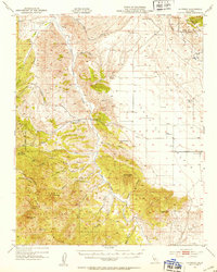
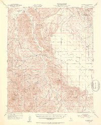
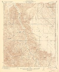
1952 Map of La Panza
USGS Topo · Published 1953About this map
San Juan Creek carves a central path through this landscape, dividing the high ridges of the Temblor Range in the east from the heavily wooded canyons of the Los Padres National Forest in the west. This 1952 culture revision by the U.S. Geological Survey documents a remote section of the California coast ranges where ranching and early petroleum exploration defined the local economy. Established outposts like La Panza Ranch, French Camp, and Pinole Ranch serve as primary landmarks in a region largely defined by its drainage basins, including Navajo Creek and Bitterwater Creek. The presence of several springs, such as Mustang Spring and Pinole Spring, highlights the critical importance of water sources for both livestock and travelers. Geologic features like Syncline Hill and the rugged Castle Crags further illustrate the complex topography that characterizes this part of San Luis Obispo County.
Find a feature on this map
42 named features on this map. Tap any name to fly to it.
Don’t see what you’re looking for? This feature index may not catch every label — zoom into the map to look around manually.
Map Details
Editions of this 1952 La Panza Map
3 editions found

Other maps of this area

1912 · McKittrick
USGS Topo · 1:125,000

1914 · Lost Hills
USGS Topo · 1:125,000

1914 · Cholame
USGS Topo · 1:125,000

1915 · Cholame
USGS Topo · 1:125,000

1917 · Cholame
USGS Topo · 1:125,000

1922 · Pozo
USGS Topo · 1:62,500

1922 · Nipomo
USGS Topo · 1:62,500

1932 · La Panza
USGS Topo · 1:48,000

1935 · La Panza
USGS Topo · 1:62,500
1936 · La Panza
USGS Topo · 1:62,500