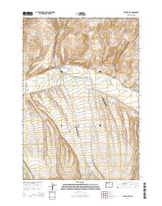
2014 Map of Prairie City
USGS Topo · Published 2014About this map
Prairie City occupies a strategic position where the John Day River meets several significant mountain drainages in eastern Oregon. The landscape is defined by the agricultural and ranching infrastructure of the valley floor, specifically noted by the network of The Mill Ditch and the proximity of Prairie City Bench to the south. Local history is anchored by the presence of McHaley Cem and the Prairie City Cem, which sit near the northern edge of town. Aviation and land use are represented by the Hi Country No 2 Airport and Oxbow Ranch Airport, illustrating how this mountain community maintains connections across the valley. Numerous creeks, including Strawberry Cr, Dixie Cr, and Jeff Davis Cr, carve through the surrounding terrain, feeding into the primary river system that historically sustained the region's development.
Find a feature on this map
48 named features on this map. Tap any name to fly to it.
Don’t see what you’re looking for? This feature index may not catch every label — zoom into the map to look around manually.
Map Details
Editions of this 2014 Prairie City Map
This is the sole edition of this map. No revisions or reprints were ever made.
Other maps of this area

1940 · John Day
USGS Topo · 1:62,500

1943 · John Day
USGS Topo · 1:62,500

1949 · Susanville
USGS Topo · 1:62,500

1951 · Susanville
USGS Topo · 1:62,500

1951 · Bates
USGS Topo · 1:62,500

1955 · Canyon City
USGS Topo · 1:250,000

1959 · Canyon City
USGS Topo · 1:250,000

1959 · Prairie City
USGS Topo · 1:62,500
1972 · Castle Creek
USGS Topo · 1:24,000
1972 · Pine Creek Mtn
USGS Topo · 1:24,000