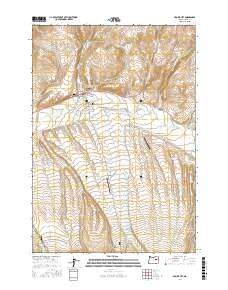
2017 Map of Prairie City
USGS Topo · Published 2017About this map
Prairie City serves as the focal point of this Grant County landscape, situated along the upper reaches of the John Day River. The town's grid is clearly defined by historical thoroughfares like Front St and S Main St, while the surrounding valley floor reveals a sophisticated water management system including The Mill Ditch and the Prairie City Reservoir. To the south and west, the terrain rises toward the Prairie City Bench, cut by numerous drainage features such as Strawberry Creek, Sharp Creek, and Shaw Gulch.
Find a feature on this map
47 named features on this map. Tap any name to fly to it.
Don’t see what you’re looking for? This feature index may not catch every label — zoom into the map to look around manually.
Map Details
Editions of this 2017 Prairie City Map
This is the sole edition of this map. No revisions or reprints were ever made.
Other maps of this area

1940 · John Day
USGS Topo · 1:62,500

1943 · John Day
USGS Topo · 1:62,500

1949 · Susanville
USGS Topo · 1:62,500

1951 · Susanville
USGS Topo · 1:62,500

1951 · Bates
USGS Topo · 1:62,500

1955 · Canyon City
USGS Topo · 1:250,000

1959 · Canyon City
USGS Topo · 1:250,000

1959 · Prairie City
USGS Topo · 1:62,500
1972 · Castle Creek
USGS Topo · 1:24,000
1972 · Pine Creek Mtn
USGS Topo · 1:24,000