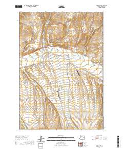
2020 Map of Prairie City
USGS Topo · Published 2020About this map
Prairie City serves as the focal point of this Grant County landscape, situated where the valley floor meets the rising elevations of the Strawberry Mountains. The settlement's street grid, including Front St and S Main St, is clearly defined north of the John Day River. Agricultural and industrial water management is evident through the path of The Mill Ditch, which traverses the flats south of town. Genealogy researchers will find both the McHaley Cem and the Prairie City Cem recorded near the main townsite.
Find a feature on this map
46 named features on this map. Tap any name to fly to it.
Don’t see what you’re looking for? This feature index may not catch every label — zoom into the map to look around manually.
Map Details
Editions of this 2020 Prairie City Map
This is the sole edition of this map. No revisions or reprints were ever made.
Other maps of this area

1940 · John Day
USGS Topo · 1:62,500

1943 · John Day
USGS Topo · 1:62,500

1949 · Susanville
USGS Topo · 1:62,500

1951 · Susanville
USGS Topo · 1:62,500

1951 · Bates
USGS Topo · 1:62,500

1955 · Canyon City
USGS Topo · 1:250,000

1959 · Canyon City
USGS Topo · 1:250,000

1959 · Prairie City
USGS Topo · 1:62,500
1972 · Castle Creek
USGS Topo · 1:24,000
1972 · Pine Creek Mtn
USGS Topo · 1:24,000