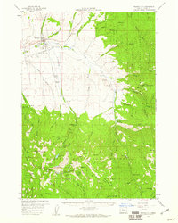
1959 Map of Prairie City
USGS Topo · Published 1961About this map
Prairie City anchors this Grant County landscape where the John Day River flows through a valley defined by timber and mining resources in the late 1950s. The town shows its industrial character with a prominent Mill, a Sewage Disposal plant, and a Gaging Sta along the water. To the south, the topography rises sharply into the Malheur National Forest and the Strawberry Mountain Wilderness, a high-elevation region marked by landmarks like Strawberry Mtn and Wildcat Basin.
Find a feature on this map
85 named features on this map. Tap any name to fly to it.
Don’t see what you’re looking for? This feature index may not catch every label — zoom into the map to look around manually.
Map Details
Editions of this 1959 Prairie City Map
4 editions found
Other maps of this area

1901 · Sumpter
USGS Topo · 1:125,000

1908 · Ironside Mountain
USGS Topo · 1:125,000

1940 · John Day
USGS Topo · 1:62,500

1943 · John Day
USGS Topo · 1:62,500

1949 · Susanville
USGS Topo · 1:62,500

1951 · Susanville
USGS Topo · 1:62,500

1951 · Bates
USGS Topo · 1:62,500

1955 · Canyon City
USGS Topo · 1:250,000

1959 · Canyon City
USGS Topo · 1:250,000

1959 · Prairie City
USGS Topo · 1:62,500