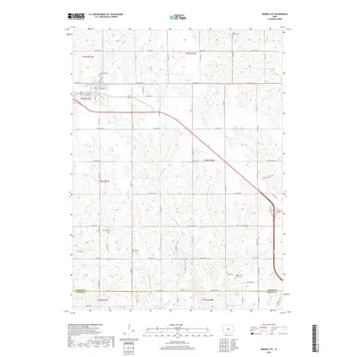
2018 Map of Prairie City
USGS Topo · Published 2018About this map
Prairie City anchors this portion of Jasper County, exhibiting a grid of streets such as W South St and E Jefferson St that give way to the expansive agricultural sections of Des Moines Township. The landscape is defined by the branching tributaries of the Des Moines River watershed, with Squaw Cr, Calhoun Cr, and Prairie Cr carving shallow valleys through the terrain. This 2018 survey reveals a high density of rural burial sites, which are critical for genealogical research in this region. Numerous family and community landmarks are recorded, including Mound Prairie Cem to the north and Ritter-Worth Cem near the southern border with Marion County. The road network follows the traditional section lines of the Public Land Survey System, though major routes like the diagonal passage of the local highway bisect the township, connecting the small-town core to the broader Iowa countryside.
Find a feature on this map
41 named features on this map. Tap any name to fly to it.
Don’t see what you’re looking for? This feature index may not catch every label — zoom into the map to look around manually.
Map Details
Editions of this 2018 Prairie City Map
This is the sole edition of this map. No revisions or reprints were ever made.
Other maps of this area

1909 · Knoxville
USGS Topo · 1:62,500

1910 · Milo
USGS Topo · 1:62,500

1912 · Knoxville
USGS Topo · 1:62,500

1930 · Mitchellville
USGS Topo · 1:62,500

1954 · Des Moines
USGS Topo · 1:250,000

1956 · Des Moines
USGS Topo · 1:250,000

1957 · Des Moines
USGS Topo · 1:250,000

1965 · Pleasantville
USGS Topo · 1:24,000

1965 · Prairie City
USGS Topo · 1:24,000

1965 · Newton
USGS Topo · 1:24,000
Featured Places
- Prairie City, IA
- Red Rock Township, IA
- Mound Prairie Township, IA
- Washington Township, IA
- Fairview Township, IA