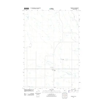
2012 Map of Prairie City
USGS Topo · Published 2012About this map
Prairie City and Strool serve as the primary hubs in this Perkins County landscape, situated where the high plains meet the intricate drainage of the Thunder Butte Cr system. The geography is defined by a sparse but essential network of rural roads, including Divide Rd and Prairie City Rd, which connect isolated homesteads across the grasslands. The presence of both the Haney Landing Strip and Carr Landing Field underscores the importance of aviation for transport and ranching operations in this expansive territory. Waterways like S Br Thunder Butte Cr carve winding paths through the terrain, dictating the placement of the early 21st-century cattle-country infrastructure.
Find a feature on this map
12 named features on this map. Tap any name to fly to it.
Don’t see what you’re looking for? This feature index may not catch every label — zoom into the map to look around manually.
Map Details
Editions of this 2012 Prairie City Map
This is the sole edition of this map. No revisions or reprints were ever made.
Other maps of this area

1954 · Lemmon
USGS Topo · 1:250,000

1957 · Lemmon
USGS Topo · 1:250,000

1983 · Grandmas Butte
USGS Topo · 1:24,000

1983 · Prairie City NE
USGS Topo · 1:24,000
1983 · Prairie City NW
USGS Topo · 1:24,000

1983 · Sorum NE
USGS Topo · 1:24,000
1983 · Sorum
USGS Topo · 1:24,000

1983 · Little Nasty Creek
USGS Topo · 1:24,000

1983 · Daviston
USGS Topo · 1:24,000
1983 · White Hill
USGS Topo · 1:24,000