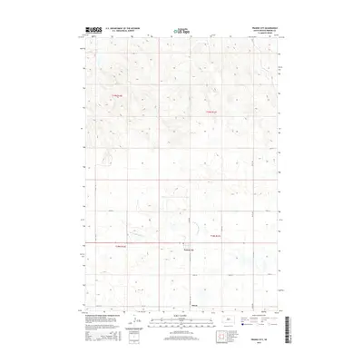
2015 Map of Prairie City
USGS Topo · Published 2015About this map
Prairie City and Strool anchor this Perkins County landscape, sitting as central points of settlement within the northwestern South Dakota plains. The area is defined by the drainage of S Br Thunder Butte Cr, which winds through the central portion of the quadrangle. The land is organized by a precise grid of rural roads, including Prairie City Rd and 159th Ave, reflecting the systematic township and range divisions of t18n r11e and surrounding sections. This 2015 survey illustrates the enduring agricultural layout of the region, where the vast open spaces are punctuated by these small, scattered community centers and a network of gravel and section-line roads that have served local ranching and farming interests for generations.
Find a feature on this map
16 named features on this map. Tap any name to fly to it.
Don’t see what you’re looking for? This feature index may not catch every label — zoom into the map to look around manually.
Map Details
Editions of this 2015 Prairie City Map
This is the sole edition of this map. No revisions or reprints were ever made.
Other maps of this area

1954 · Lemmon
USGS Topo · 1:250,000

1957 · Lemmon
USGS Topo · 1:250,000

1983 · Grandmas Butte
USGS Topo · 1:24,000

1983 · Prairie City NE
USGS Topo · 1:24,000
1983 · Prairie City NW
USGS Topo · 1:24,000

1983 · Sorum NE
USGS Topo · 1:24,000
1983 · Sorum
USGS Topo · 1:24,000

1983 · Little Nasty Creek
USGS Topo · 1:24,000

1983 · Daviston
USGS Topo · 1:24,000
1983 · White Hill
USGS Topo · 1:24,000