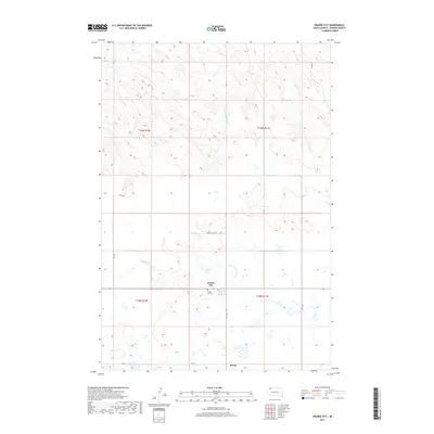
2017 Map of Prairie City
USGS Topo · Published 2017About this map
Prairie City and Strool anchor this portion of Perkins County, representing the quiet, persistent settlement patterns of the high plains. The landscape is defined by the drainage of the S Br Thunder Butte Cr, which carves through the terrain between the sections of t18n r10e and t19n r11e. Local history is centered at the Prairie City Cem, situated just south of the main settlement and accessible via Prairie City Rd. The survey illustrates the rigid section lines of the Public Land Survey System, with gravel and dirt routes like 159th Ave and 131st St providing the primary grid for ranching and agricultural access. This map shows a region where the vast geography is marked primarily by small community hubs and the essential watercourses that sustain them.
Find a feature on this map
13 named features on this map. Tap any name to fly to it.
Don’t see what you’re looking for? This feature index may not catch every label — zoom into the map to look around manually.
Map Details
Editions of this 2017 Prairie City Map
This is the sole edition of this map. No revisions or reprints were ever made.
Other maps of this area

1954 · Lemmon
USGS Topo · 1:250,000

1957 · Lemmon
USGS Topo · 1:250,000

1983 · Grandmas Butte
USGS Topo · 1:24,000

1983 · Prairie City NE
USGS Topo · 1:24,000
1983 · Prairie City NW
USGS Topo · 1:24,000

1983 · Sorum NE
USGS Topo · 1:24,000
1983 · Sorum
USGS Topo · 1:24,000

1983 · Little Nasty Creek
USGS Topo · 1:24,000

1983 · Daviston
USGS Topo · 1:24,000
1983 · White Hill
USGS Topo · 1:24,000