1970 Map of Prairie Du Rocher
USGS Topo · Published 1988About this map
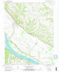
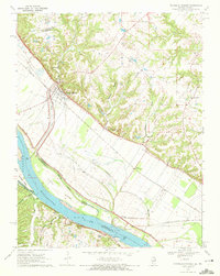
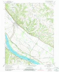
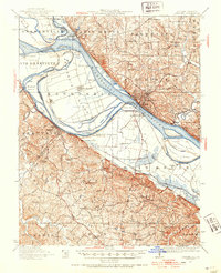
Prairie du Rocher and its surrounding river bottoms are defined by a complex network of man-made and natural features along the Mississippi River. The landscape is bisected by the Missouri Pacific and St Louis - San Francisco railroads, which facilitated local industry like the Mines and Quarry near Danley. The historic significance of the area is anchored by the Modoc Rock Shelter National Historic Site, located where the bluffs meet the floodplain. Drainage patterns are meticulously managed through an extensive Levee system and man-made channels like The Discharge, which navigate the space between the river's islands, including Turkey Island and Schmidts Island. Small river-linked settlements like Kellogg, Thomure, and Modoc are connected to the Missouri side via a Ferry near Little Rock Landing, illustrating the vital river-and-rail economy of the mid-20th century.
Find a feature on this map
35 named features on this map. Tap any name to fly to it.
Don’t see what you’re looking for? This feature index may not catch every label — zoom into the map to look around manually.
Map Details
Editions of this 1970 Prairie Du Rocher Map
3 editions found
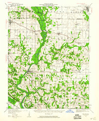
Other maps of this area

1907 · Weingarten
USGS Topo · 1:62,500

1909 · Weingarten
USGS Topo · 1:62,500

1912 · Baldwin
USGS Topo · 1:62,500

1914 · Baldwin
USGS Topo · 1:62,500

1915 · Renault
USGS Topo · 1:62,500

1915 · Chester
USGS Topo · 1:62,500

1940 · Renault
USGS Topo · 1:62,500
1942 · Baldwin
USGS Topo · 1:62,500
1947 · Chester
USGS Topo · 1:62,500

1949 · Saint Louis
USGS Topo · 1:250,000