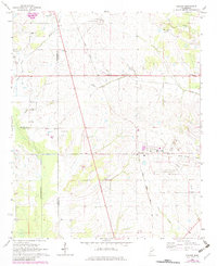
1966 Map of Prairie
USGS Topo · Published 1982About this map
The community of Prairie and the nearby hamlet of Gibson anchor this mid-century topographic survey of the Monroe County landscape. The area is defined by a dense network of country churches and burial grounds, serving as a significant record for genealogical research. Prominent local landmarks include Baptist Grove Ch, Mt Zion Ch, and the Aberdeen-Prairie Sch, alongside numerous family and church cemeteries such as Patterson Cem and Coleman Cem.
Find a feature on this map
34 named features on this map. Tap any name to fly to it.
Don’t see what you’re looking for? This feature index may not catch every label — zoom into the map to look around manually.
Map Details
Editions of this 1966 Prairie Map
2 editions found
Other maps of this area

1953 · West Point
USGS Topo · 1:250,000

1958 · West Point
USGS Topo · 1:250,000

1959 · West Point
USGS Topo · 1:62,500

1959 · Van Vleet
USGS Topo · 1:62,500

1959 · Pheba
USGS Topo · 1:62,500

1963 · West Point
USGS Topo · 1:250,000

1965 · Egypt
USGS Topo · 1:24,000

1966 · Aberdeen
USGS Topo · 1:24,000

1966 · Wren
USGS Topo · 1:24,000

1966 · Prairie
USGS Topo · 1:24,000