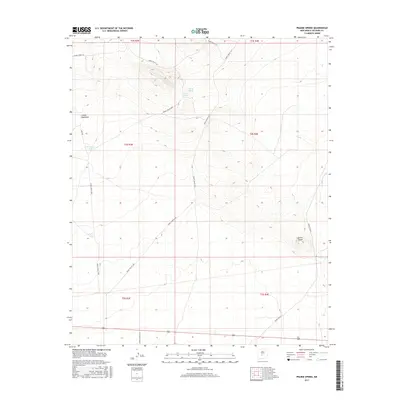
2017 Map of Prairie Spring
USGS Topo · Published 2017About this map
Prairie Spring and Llano Spring define the hydrological landscape of this high desert region in Socorro County, where water sources were critical for range management and early travel. The terrain is characterized by geological formations like Cerro Pardo and the drainage of Canon Quemado, illustrating the physical challenges of the northern Chihuahuan Desert. This 2017 survey details the complex modern road network developed for the White Sands Missile Range, including WSMR P Route 18 and WSMR S Route 3617. These routes, alongside established ranching features like Ferrandez Tank and Fisher Tank, show the convergence of military infrastructure and traditional land use. The map provides a clear picture of how government land management and military activity have shaped the accessibility and utility of this arid terrain.
Find a feature on this map
18 named features on this map. Tap any name to fly to it.
Don’t see what you’re looking for? This feature index may not catch every label — zoom into the map to look around manually.
Map Details
Editions of this 2017 Prairie Spring Map
This is the sole edition of this map. No revisions or reprints were ever made.
Other maps of this area

1916 · La Joya
USGS Topo · 1:125,000

1918 · Oscura Peak
USGS Topo · 1:125,000

1948 · Carthage
USGS Topo · 1:62,500

1948 · Bingham
USGS Topo · 1:62,500

1954 · Tularosa
USGS Topo · 1:250,000

1954 · Socorro
USGS Topo · 1:250,000

1958 · Socorro
USGS Topo · 1:250,000

1958 · Tularosa
USGS Topo · 1:250,000

1962 · Socorro
USGS Topo · 1:250,000
1972 · Bustos Well
USGS Topo · 1:24,000