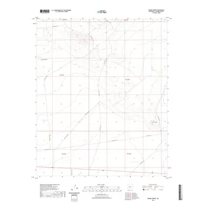
2020 Map of Prairie Spring
USGS Topo · Published 2020About this map
Prairie Spring and Llano Spring provide the primary water sources in this high-desert region of Socorro County, where the landscape is defined by drainage patterns and military access routes. The area is dominated by the terrain of Cañon Quemado to the northwest and the isolated prominence of Cerro Pardo in the southeast. Located within a government reservation, the land is crisscrossed by a network of White Sands Missile Range (WSMR) roads, including WSMR P Route 18 and WSMR P Route 41, which link various survey sections. Local infrastructure is minimal, consisting largely of cattle tanks like Fisher Tank and the specialized transit routes that serve the military range. This survey provides a precise look at the township and range divisions across the T3S, T4S, and T5S boundaries, illustrating the intersection of natural geography and managed federal territory.
Find a feature on this map
17 named features on this map. Tap any name to fly to it.
Don’t see what you’re looking for? This feature index may not catch every label — zoom into the map to look around manually.
Map Details
Editions of this 2020 Prairie Spring Map
This is the sole edition of this map. No revisions or reprints were ever made.
Other maps of this area

1916 · La Joya
USGS Topo · 1:125,000

1918 · Oscura Peak
USGS Topo · 1:125,000

1948 · Carthage
USGS Topo · 1:62,500

1948 · Bingham
USGS Topo · 1:62,500

1954 · Tularosa
USGS Topo · 1:250,000

1954 · Socorro
USGS Topo · 1:250,000

1958 · Socorro
USGS Topo · 1:250,000

1958 · Tularosa
USGS Topo · 1:250,000

1962 · Socorro
USGS Topo · 1:250,000
1972 · Bustos Well
USGS Topo · 1:24,000