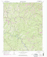
1963 Map of Prater
USGS Topo · Published 1978About this map
The winding course of the Russell Fork river carves through the Cumberland Plateau along the Buchanan and Dickenson line, anchoring a landscape defined by narrow hollows and steep ridges. In the early 1960s, small settlements like Prater, Vicey, and Viers were connected by a network of creekside roads and ridge-top gaps such as Upper Greenbrier Gap and Lovers Gap. This era reveals the local reliance on community institutions, with several small schools like the Lower Greenbrier Sch and War Fork Sch serving the remote valleys. Land use is deeply tied to the terrain, showing the emergence of Strip Mines near Poplar Gap alongside traditional family landmarks like the Deel Cem and Owens Cem. The northern edge of the map identifies the Grundy Airport and a Lookout Tower, providing early markers of regional infrastructure and fire management.
Find a feature on this map
89 named features on this map. Tap any name to fly to it.
Don’t see what you’re looking for? This feature index may not catch every label — zoom into the map to look around manually.
Map Details
Editions of this 1963 Prater Map
Other maps of this area

1886 · Grundy
USGS Topo · 1:125,000

1890 · Grundy
USGS Topo · 1:125,000

1892 · Grundy
USGS Topo · 1:125,000

1913 · Clintwood
USGS Topo · 1:62,500

1914 · Bucu
USGS Topo · 1:48,000

1914 · Hurley
USGS Topo · 1:48,000

1915 · Clintwood
USGS Topo · 1:62,500

1915 · Regina
USGS Topo · 1:48,000

1915 · Hurley
USGS Topo · 1:48,000

1916 · Bucu
USGS Topo · 1:62,500