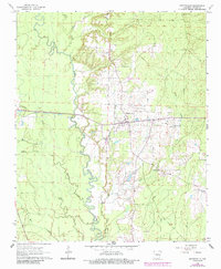
1963 Map of Prattsville
USGS Topo · Published 1984About this map
The Saline River winds through this Central Arkansas landscape, forming a complex system of oxbows and swampy lowlands that define the region's geography. Historically centered around the settlement of Prattsville, the area shows a distinct pattern of upland development away from the river's flood-prone banks. Local life is anchored by landmarks like the Sweet Home Ch and the Cooper Sch, which serve as vital genealogical markers for the rural population of northern Grant County during the early 1960s. To the southeast, Philadelphia Cem and Polk Creek mark a shift toward more broken terrain. The map also documents local industry through several Gravel Pit operations and the presence of a Lookout Tower positioned for timber management. Later photorevisions added in purple highlight subtle changes in road alignments and woodland cover, contrasting the 1960s baseline with early 1980s developments.
Find a feature on this map
16 named features on this map. Tap any name to fly to it.
Don’t see what you’re looking for? This feature index may not catch every label — zoom into the map to look around manually.
Map Details
Editions of this 1963 Prattsville Map
2 editions found
Other maps of this area

1955 · Little Rock
USGS Topo · 1:250,000

1956 · Little Rock
USGS Topo · 1:250,000

1960 · Little Rock
USGS Topo · 1:250,000

1963 · Traskwood
USGS Topo · 1:24,000

1963 · Prattsville
USGS Topo · 1:24,000
1963 · Tull
USGS Topo · 1:24,000

1964 · Poyen
USGS Topo · 1:24,000

1964 · Little Rock
USGS Topo · 1:250,000

1964 · Sheridan
USGS Topo · 1:24,000

1964 · Belfast
USGS Topo · 1:24,000