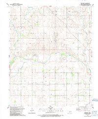
1989 Map of Prentiss
USGS Topo · Published 1989About this map
Prentiss sits at the intersection of rural Beckham County life, where the Oklahoma landscape is defined by the winding course of the North Fork Red River. This 1980s-era topographic representation reveals an economy deeply tied to energy extraction, with extensive gas fields, numerous Gas Wells, and an intricate network of pipelines crossing the territory. The map documents the social anchors of the rural population, such as the Bulo Community Center and New Life Ch, which serve the surrounding farming and ranching community. The drainage patterns of the southern plains are clearly visible, with W Buffalo Creek, Middle Buffalo Creek, and Starvation Creek cutting through the terrain toward the river. For those tracing regional history, the presence of the Pioneer Cem in the southern portion of the quadrangle offers a fixed point of reference for early settlement roots in this portion of Western Oklahoma.
Find a feature on this map
21 named features on this map. Tap any name to fly to it.
Don’t see what you’re looking for? This feature index may not catch every label — zoom into the map to look around manually.
Map Details
Editions of this 1989 Prentiss Map
This is the sole edition of this map. No revisions or reprints were ever made.
Other maps of this area

1955 · Clinton
USGS Topo · 1:250,000

1957 · Clinton
USGS Topo · 1:250,000

1960 · Sweetwater
USGS Topo · 1:62,500

1960 · Sayre
USGS Topo · 1:62,500

1961 · Willow
USGS Topo · 1:62,500

1961 · Erick
USGS Topo · 1:62,500

1985 · Elk City
USGS Topo · 1:100,000
1988 · Grimes
USGS Topo · 1:24,000
1989 · Erick
USGS Topo · 1:24,000
1989 · Delhi
USGS Topo · 1:24,000