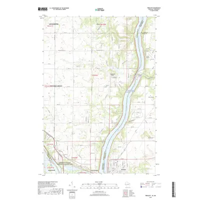
2019 Map of Prescott
USGS Topo · Published 2019About this map
The confluence of the Mississippi River and the St. Croix Wild and Scenic River defines this landscape where Minnesota and Wisconsin meet. At the southern tip of the peninsula sits Point Douglas, a strategic point just across the water from Prescott and Hastings. The terrain is characterized by the widening Lake Saint Croix and the smaller Conley Lake to the west, with the Mississippi National River and Recreation Area protecting the riverfront. Further inland, the agricultural character of Washington County is visible near Basswood Grove and Afton. For genealogists, several burial grounds are documented, including Saint Mary's Episcopal Cem, Evergreen Cem, and Johnson Cem. The map also captures local topography such as Barkley Coulee and Dills Mound, along with the Kinnickinnic River where it meets the St. Croix.
Find a feature on this map
64 named features on this map. Tap any name to fly to it.
Don’t see what you’re looking for? This feature index may not catch every label — zoom into the map to look around manually.
Map Details
Editions of this 2019 Prescott Map
This is the sole edition of this map. No revisions or reprints were ever made.
Other maps of this area

1944 · Red Wing
USGS Topo · 1:62,500

1946 · Hudson
USGS Topo · 1:62,500

1946 · River Falls
USGS Topo · 1:62,500

1949 · River Falls
USGS Topo · 1:62,500

1949 · Hudson
USGS Topo · 1:62,500

1949 · Lake Elmo
USGS Topo · 1:24,000

1949 · Hudson
USGS Topo · 1:24,000

1950 · Lake Elmo
USGS Topo · 1:24,000

1950 · Hudson
USGS Topo · 1:24,000

1950 · St Paul Park
USGS Topo · 1:24,000